Eight Days Lemosho Route
8 days—Kilimanjaro trekking via lemosho route
$1700-1850 USD
pp
Safari summary
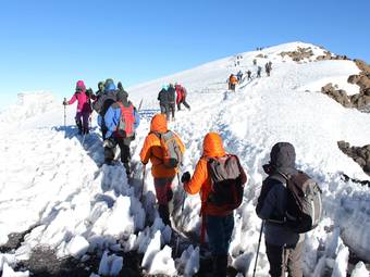
he Lemosho route is one of our preferred routes due to its low traffic, beautiful scenery and a high summit success rate.The Lemosho route joins the Machame route at Shira 2 Camp and then follows the same route through the southern circuit and descending at Mweka Gate.
About this tour
| Tour type | Custom, tailor-made, private | |
| Main focus | Hiking | trekking | |
| Activity level | Strenuous activity | |
| Best months | January, February, March, April, June, July, August, September, October, December | |
| Countries | ||
| Parks |
Fine details
Safari highlights
- Hiking | trekking
What’s included?
- Accommodation
- Airport transfers
- All drinks
- Meals
- Park fees
- Private vehicle and driver
What’s not included?
- Alcoholic beverages
- Hot air balloons
- International flights
- Laundry
- Premium alcoholic beverages
- Private vehicle and driver
- Spa treatments
- Tips and gratuities
- Visas
Itinerary
Lemosho Gate to Mti Mkubw
Elevation: 7,742 ft to 9,498 ft meters(2100m to 2700m) Distance: 6 km/4 miles Hiking Time: 3-4 hours Habitat: Rain Forest We depart Moshi for Londorossi Gate, which takes about 4 hours, where you will complete entry formalities. Then drive to the Lemosho trailhead. Upon arrival at trailhead, we begin hiking through undisturbed forest which winds to the first camp site.
camping at Mountain
Mti Mkubwa to Shira 1 Camp
Elevation: 9,498 ft to 11,500 ft meters(2700m to 3600m) Distance: 8 km/ 5miles Hiking Time 5-6 hours Habitat: Health We continue on the trail leading out of the rain forest and into a savannah of tall grasses, heather and volcanic rock draped with lichen beards. As we ascend through the lush rolling hills and cross several streams, we reach the Shira Ridge before dropping gently down to Shira 1 Camp. Here we catch our first glimpse of Kibo across the plateau.
camping at Mountain
Shira 1 Camp to Shira 2 Camp
Elevation: 11,500 ft to 13,800 ft meters(3600m to 3850m) Distance: 11 km/ 7 miles Hiking Time: 5-7 hours Habitat: Heath We explore the Shira Plateau for a full day. It is a gentle walk east on moorland meadows towards Shira 2 Camp. Then we will have an option to sport and acclimatize at Shira Cathedral, a little used site on the base of Lent Hills. A variety of walks are available on Lent Hills making this an excellent acclimatization opportunity.
camping at Mountain
Shira 2 to Lava Tower
Elevation: 13,800 ft to 15,190 ft meters(3850m to 4600m) Distance: 7 km/4 miles Hiking Time: 4-5 hours Habitat: Alpine Desert Lava Tower to Barranco Camp Elevation: 15,190 ft to 13,044 ft meters(4600m to 3900m) Distance: 3 km/2 miles Hiking Time: 2-3 hours Habitat: Alpine Desert We begin the day climbing up a ridge and then head southeast towards the Lava Tower – a 300 ft tall volcanic rock formation.
camping at Mountain
Barranco Camp to Karanga Camp
Elevation: 13,044 ft to 13,106 ft meters(3900m to 4000m) Distance: 5 km/3 miles Hiking Time: 4-5 hours Habitat: Alpine Desert We begin the day by descending into a ravine to the base of the Great Barranco Wall. Then we climb the non-technical but steep, nearly 900 ft cliff. From the top of the Barranco Wall we cross a series of hills and valleys until we descend sharply into Karanga Valley. One more steep climb up leads us to Karanga Camp. This is a shorter day meant for acclimatization.
camping at Mountain
Karanga Camp to Barafu Camp
Elevation: 13,106 ft to 15,331 ft meters(4000m to 4600m) Distance: 4 km/2 miles Hiking Time: 4-5 hours Habitat: Alpine Desert We leave Karanga and hit the junction which connects with the Mweka Trail. We continue up to the rocky section to Barafu Hut. At this point, you have completed the Southern Circuit, which offers views of the summit from many different angles. Here we make camp, rest and enjoy an early dinner to prepare for the summit day
camping at Mountain
Barafu Camp to Uhuru Peak
Elevation: 15,331 ft to 19,341 ft meters(4600m to 5895m) Distance: 5 km/3 miles Hiking Time: 7-8 hours Habitat: Arctic Uhuru Peak to Mweka Camp Elevation: 19,341 ft to 10,065 ft meters(5895m to 3000m) Distance: 12 km/7 miles Hiking Time: 4-6 hours Habitat: Rain Forest Very early in the morning (around midnight), we begin our push to the summit. This is the most mentally and physically challenging portion of the trek. The wind and cold at this elevation and time of day can be extreme.
camping at Mountain
Mweka Camp to Mweka Gate
Elevation: 10,065 ft to 5,380 ft meters(3000m to 1650m) Distance: 10 km/6 miles Hiking Time: 3-4 hours Habitat: Rain Forest On our last day, we continue the descent to Mweka Gate and collect the summit certificates. At lower elevations, it can be wet and muddy. From the gate, we continue another hour to Mweka Village. A vehicle will meet us at Mweka Village to drive us back to the hotel in Moshi.
Hotel around Moshi Town
Here are the latest tours by Kili Highlands Explorer.
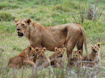
Four Days - Wildlife Safari
Tour by: Kili Highlands Explorer
Countries:

Focus: Game drives
Seven Days Machame Route
Tour by: Kili Highlands Explorer
Countries:
Focus: Hiking | trekking